South Dublin County Libraries
Please use this identifier to cite or link to this item:
https://hdl.handle.net/10599/4961Full metadata record
| DC Field | Value | Language |
|---|---|---|
| dc.contributor.author | Taylor, John | en_IE |
| dc.contributor.other | Courtesy of Andrew Bonar Law | en_IE |
| dc.coverage.spatial | Rathfarnham, Ballyboden, Churchtown, Templeogue | en_IE |
| dc.coverage.temporal | 1816 | en_IE |
| dc.date.accessioned | 2010-02-23T12:54:21Z | - |
| dc.date.available | 2010-02-23T12:54:21Z | - |
| dc.date.issued | 2009-09-07T16:32:32Z | en_IE |
| dc.identifier.other | wm_Taylor_Rathfarnham.jpg | |
| dc.identifier.uri | https://hdl.handle.net/10599/4961 | - |
| dc.description | Portion of John Taylor's map of Dublin, showing Rathfarnham and surrounding area | en_IE |
| dc.format | .jpg | en_IE |
| dc.language.iso | English | en_IE |
| dc.publisher | John Taylor | en_IE |
| dc.subject | map | en_IE |
| dc.subject | Ely Demesne | en_IE |
| dc.subject | Rathfarnham Castle | en_IE |
| dc.subject | Newtown | en_IE |
| dc.subject | Cypress Grove | en_IE |
| dc.subject | Kilvere House | en_IE |
| dc.subject | Templeogue Bridge | en_IE |
| dc.subject | Butterfield Lane | en_IE |
| dc.subject | Washington Lodge | en_IE |
| dc.subject | Old Orchard | en_IE |
| dc.subject | Willbrook | en_IE |
| dc.subject | Nutgrove school | en_IE |
| dc.subject | Wintebarn | en_IE |
| dc.subject | Landscape | en_IE |
| dc.subject | Belfield | en_IE |
| dc.subject | Ballyroan | en_IE |
| dc.subject | Marley House | en_IE |
| dc.subject | Elm Park | en_IE |
| dc.subject | Elm Grove | en_IE |
| dc.subject | Elm Cottage | en_IE |
| dc.subject | Whitechurch Mill | en_IE |
| dc.subject | Waterfall | en_IE |
| dc.subject | Sally Garden | en_IE |
| dc.subject | Brooklawn Mills | en_IE |
| dc.subject | Barton Lodge | en_IE |
| dc.subject | Sweetmount | en_IE |
| dc.subject | Rathfarnham House | en_IE |
| dc.subject | Fields of Oden | en_IE |
| dc.subject | Lands of Ballybowden | en_IE |
| dc.subject | Woodbine. | en_IE |
| dc.title | Taylor's map of the environs of Dublin extending 10 to 14 miles from the castle by actual survey on a scale of 2 inches to one mile [Rathfarnham] | en_IE |
| dc.type | image | en_IE |
| Appears in Collections: | Maps Published Items | |
Files in This Item:
| File | Description | Size | Format | |
|---|---|---|---|---|
| wm_Taylor_Rathfarnham.jpg | 490.15 kB | JPEG | 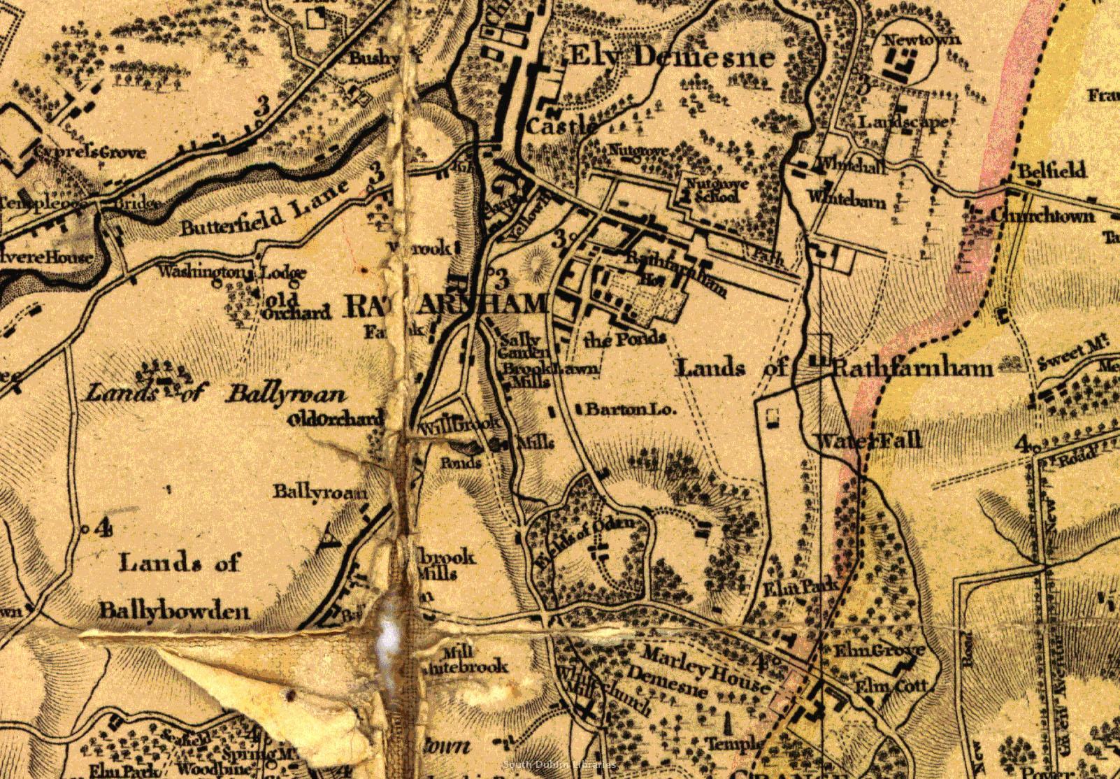 View/Open |
This item is protected by original copyright |
Items in Source are protected by copyright, with all rights reserved, unless otherwise indicated.